Mobility Initiatives & Visual Improvements
Mobility Initiatives & Visual Improvements Committee
First Monday of the Month
11:00 a.m. – 5020 Montrose, Suite 311
 The district has a number of mobility and visual improvement projects underway. These improvements include bridge lighting improvements to be completed on the seven bridges in the Montrose area that cross US 59, Phase 1 of the identification markers, and esplanades enhancements which are already underway. It is the intent of the Montrose District board to complete the bridge lighting project, and Phase 1 of the ID Markers and esplanade enhancements just prior to the Super Bowl in February 2017. Each of these projects will add a series of new and exciting elements to the Montrose landscape and reinforce recognition of Montrose as one of the most unique and desirable destinations in the Houston region.
Click here, to learn more about the Bridge Lighting Project.
To learn more, view the Montrose Visual Enhancements 2016 PDF.
Special Parking Area Application
At the request of the Montrose Management District, Walter P Moore conducted a comprehensive parking study within the District focusing on the commercial area centered on the intersection of Montrose Boulevard and Westheimer Road. The study’s west/east parameters are between Mandell Street and Taft Street along Westheimer Road and north/south between Hyde Park Boulevard and Harold Street along Montrose Boulevard. The parking study focused on the area’s parking supply and demand, walking distances, and parking restrictions/regulations with the goal of submitting an application to be designated as a Special Parking Area as defined by the City of Houston’s Code of Ordinances Chapter 26-511.
To learn more, view the entire SPA Application and Presentation for the Neartown Civic Association.
View the Monstrose Special Parking Area Application Presentation from the Plan Commission meeting.

Mobility Study
At the request of the East Montrose Management District, Walter P Moore conducted a comprehensive district-wide mobility study. The District is an area of diverse land uses. Located just west of Downtown Houston, it is bounded by West Dallas to the north, Burlington or Spur 527 to the east, US 59 to the south, and Montrose or Graustark to the west.
 The boundaries encompass an area of approximately one square mile and it is predominately residential but also includes significant retail, entertainment and institutional land uses. Because the District has developed and redeveloped over several decades, there is a diversity of mobility issues to be considered in the mobility study.
The West Montrose District has also been created and the map on the home page includes both the east and west districts. Both districts have been combined into one – the Montrose Management District. Since this occurrence, Walter P. Moore has completed the transportation and mobility plan for the west side.
READ THE DISTRICT MOBILITY STUDY*»
*appendix available at the Montrose District Office.
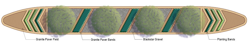
Esplanade Enhancements
The Montrose Management District has adopted multiple esplanades across the district. Many enhancements and improvements are planned for these, with 13 being completed before the Super Bowl in February 2017. The District has worked closely with the City of Houston to ensure that all plantings are within city requirements to promote visibility without sacrificing beautification.
 |
 |